
Pin Parvati Pass Trek
-
Difficulty
Difficult -
Duration
11 Days -
Maximum Altitude
17,500 ft -
Base Camp
Manali -
Best Time To visit
July-August
- 11 Days
- Trekking 110 Km
Pick Up Point: Manali
Payment Mode: Cash, UPI, Bank Transfer
Trek Info
- Region :- Himachal Pradesh
- Snow: December to March
- Trekking Km: 110 Kms
Need Help?
Call us on 9045089649
Weather Forecast
The weather during April, May and June is mostly cool and pleasant but gets chilly and cold during winters.

Have any Query?
Call Us on 9045089649
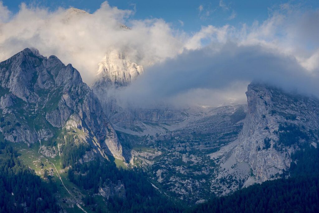
The Pin Parvati Pass (sometimes spelled Pin Parvati Pass) is a 5,319-meter mountain pass in Himachal Pradesh, India. From the woodland and green meadows of the Parvati Valley to the Buddhist communities of the Trans-Himalayan region of Spiti, the Pin Parvati Pass trek offers the most stunning crossings. You’ll be taken aback by the stark contrast in scenery, culture, plants, and fauna. In just a few hours, you’ll go from the frigid, dry upland desert of Spiti to the lush biodiversity of Parvati Valley. The bird’s eye vista from the Pin Parvati Pass will take your breath away. The Pin Parvati Trek is a once-in-a-lifetime journey that takes you from Tunda Bhuj to the marshlands of Mantalai to the alpine meadows of Odi Thach, dense forests near Kheerganga, and glaciers near the Pass. The optimal blend of Hill, Desert, and Jungle has been described.
The majority of the trekking point base camps are located in Kullu and Manali. Because those locations are easily accessible and well connected to the rest of the country.
The Pin Parvati Pass journey is without a doubt one of the most enticing trans Himalayan treks. This arduous and strenuous trail is only for experienced and physically active hikers who have completed at least two, if not three, high Himalayan multi-day camping treks. Spiti’s trans Himalayan valleys were historically difficult to reach, but the Pin Parvati pass route cuts the distance between the Kullu and Spiti valleys in half. The trail was first offered to hikers in 1993. The walk is rigorous and difficult, but the region’s splendour makes it one of the most popular Trans-Himalayan treks.
On both sides of the pass, this amazing trek offers landscapes that are radically different. The remarkable contrast between the barren and rain-streaked Pin valley (Spiti side) and the lush green Parvati valley is shown by this constantly snowbound route (Kullu side).
On this once-in-a-lifetime trek, hikers will encounter dense forests, hot springs, grazing meadows, meandering streams, moraines and glaciers, snow-capped peaks, coloured mountains, and much more. Kullu Eiger, Parvati South, Kangla Tarbo, Kullu Makalu, and West Horn are the primary peaks visible.
Day 1: Manali to Barshaini and trek to Kalga
• Manali to Barshaini and trek to Kalga
• Manali to Barshaini 4 – 5 hrs drive
• Barshaini to Kalga 1/2 hr trek
• Lunch at Manikaran (Stoppage for 1 hr)
• Leave Manali at 10 am
• Bring left luggage separately so that without wasting time we will leave Manali on time
• Networks are available at Kalga
• Some parts of trek through apple orchid
• Stay in home stay
Day 2: Kalga to Kheerganga
•Altitude Gain: 500m/ 1,650ft
• Stay in tents/ local rest house
• No Network available
• Hot water spring at Kheerganga
• Trek along with Parvati River
• Will get much maggi point on the way
• Mixed forest of Pine, Oak, Horse chestnut, Wall nut
• Less steep ascent, more of gradual ascent
Day 3 : Kheerganga to Tunda Bhuj
• Camp setup takes time due to erratic availability of water, be patient
• Gradual ascent but tiring . 3 small stream with small bridge be careful
• No shops on the way . Last day of the forest.
Day 4: Tunda Bhuj to Thakur Kuan
• Altitude Gain: 200m/ 650ft
• Most beautiful campsite of the trek
• Tricky and rocky patch on the way so walking together is mandatory
• After the tricky patch very steep ascent for 1 hr
Day 5: Thakur Kuan to Odi Thach
• 9 km trek 5-6hrs
• Altitude Gain:250m/750ft
• Easiest day of the trek <br• Pandu Bridge (Most tricky patch) comes just after 1.5 hrs of trek, to cross that bridge everyone has to be together . Most of the trail is flat walk
• Water points are available before the Pandu Bridge
• Very windy campsite
Day 6: Odi Thach to Mantalai Lake
• Altitude Gain:- 350m/ 1,200ft
• After half hour from Odi Thach a big ground comes, cross that ground from left side (ground id very muddy)
• Moraine area start just after crossing that ground
• Moraine area is steep ascent
• Mantalai Lake is the source of Parvati River
• Small temple of lord Shiva at Mantalai Lake, from temple campsite is 45 minutes far.
• Chances of getting AMS is high, keep yourself hydrate
• Swimming in the lake is not aloud and not advisable
Day 7: Mantalai Lake to Summit Camp
• Altitude Gain:- 800m/ 2,700ft
• exhausted day . Most of the part is very steep ascent
• Only two water points are available
• Just after 30 to 40 minutes of trek first water stream comes, keep floaters handy • After 3 1/2 hrs one more stream crossing
• Chances of missing is very high, never walk alone
• Camp site is most uncomfortable, camping will be on rocks
Day 8 : Summit Camp to Pin Parvati Pass
• Altitude Gain:- 350m/ 1,150ft
• Altitude Loss:- 850m/ 8,850ft
• Stay on summit maximum for 15 to 20 minutes
• Today don’t make your own route on snow, always fallow trek leader or guide (craves area)
• Today’s descent is more tricky and tiring then ascent
• One stream and one river crossing keep floaters handy and cross under the guidance of your trek leader
• After river crossing camp site is one hour far
Day 9: Pin Base to Tiya
• Altitude Loss:500m/ 1,600ft . Gradual descent
• Very beautiful campsite and windy
• Bearn land . Can see the Bhaba Pass rout On this day we’ll be trekking to Tiya which is approximately 12km.
Day 10: Tiya to Mud Drive to Kaza
• 25 km drive 1 hr
• Altitude Loss:300m/1,000ft
• Flat walk almost on the road
• Trek till Mud and drive to Kaza
• Due to no network transportation timing may get late
• Stay in Kaza (Guest house)
Day 11: Kaza to Manali
You’ll reach Manali between 6:00 pm and 7:00 pm. You can book your travel any time after 7:30 pm.
Day 1: Manali to Barshaini and trek to Kalga
When you arrive in Manali by 10 a.m. and depart for Barsheni Village, which is surrounded by thick pine forest and lush pastureland, the adventurous trip will take on a pleasant tone. You will next proceed to Kalga village, which is a half-hour journey from Barshaini. We will stop for lunch at the Manikaran Gurudwara, where you can also visit the neighbouring hot springs. The gurudwara serves hot langar, which you should absolutely taste. After lunch, we’ll travel to Barshaini, from where we’ll begin our climb to Kalga. Please note that there is internet access at Kalga and that your lodging will be at a guest’s home.
Day 2: Kalga to Kheerganga
On the second day, you will continue on the long trek from Kalga and cross the bridge where you can glimpse the River Parvati. Pin Parvati pass trek is a thrilling adventure that allows you to have fun while trekking and take in the breathtaking scenery. The track winds through dense forest and includes a steep ascent that takes more than 30 minutes. The climb continues until you reach a point when it makes a reasonable V curve and the restroom is on your left. It takes another ten minutes to hike up to Khirganga, which is located on tending pastureland. You’ll also come across a maggie spot where you may rest and refuel. The entire trail is a moderate incline through a variety of Pine, Oak, Horse Chestnut, and Walnut trees, with a few difficult sections. The walk from Kalga to Khirganga is 10 kilometers long and takes about 6-7 hours. Tents will be provided once you arrive in Khirganga.
Day 3 : Kheerganga to Tunda Bhuj
Today’s walk will begin with a tough ascent to Tunda-Bhuj, from where you can see the Parvati River flowing down the mountain’s left flank. The route will take you through a lengthy meadowland, and the chirping of birds will fill you with joy. The route from Khirganga begins with a steady incline for about 20 minutes after crossing the first creek. The temporary bridge across the mountains can then be seen. There is a tiny tent along the path where the local wholesaler sells things. After 30 minutes, you will emerge from the forest and be greeted by meadow land and a magnificent view of the dell. You’ll now follow the hill’s high crest. The trail will swirl through the hilly terrain after you reach the summit, and you will see the vast Parvati valley in front of you. This is the penultimate overpass you will encounter before arriving in Tundra-Bhuj, which is located at a high altitude of 10,500 feet above sea level. There are massive mountains covered in snow, and the scenery is breathtaking.
Day 4: Tunda Bhuj to Thakur Kuan
The scenery view of Tunda Bhuj is beautiful, but the distance is challenging because the bridge is long and time-consuming to cross. Following up the peak after crossing the bridge to the other side of the creek takes some time. The steady climb takes 15 minutes as you pass through an inclined rocky meadow region. Trekking in Manali reveals the beauty of a stunning landscape view and enhances the picturesque beauty. As you continue on the trail, you will reach a higher elevation, where the landscape view will be breathtaking. After an early morning crossing of the Pandu Bridge, take a 15-minute stroll down to the Parvati River on your right, passing past the fields. By dusk, you will have arrived at the Thakur Kuan, which is located at a high altitude of 11,000 feet above sea level.
Day 5: Thakur Kuan to Odi Thach
After a good night’s sleep, you’ll feel fantastic the next morning as you prepare for the activities ahead. You’ll pass through a terrain zone before encountering many streams. On the left side, you will locate the Parvati River, which is really picturesque. Then you’ll enter the Thakur Kuan region, which is surrounded by orchard blossoms and small trees and may be seen on the other side of the Parvati River. The Pandu bridge, which is the most difficult stretch, is reached after 1.5 hours of walking.
Day 6: Odi Thach to Mantalai Lake
We’ll be covering a distance of 12 kilometres today, which should take us about 7-8 hours. This trail is a little muddy and can be treacherous at times, so go with caution. After crossing the muddy surface, you will get to the moraine area. It has a difficult ascent that needs a lot of physical effort. As a result, it’s critical to climb at your own pace. The Parvati River begins near Mantalai Lake, where you can also visit a tiny temple. The next campsite is only 45 minutes away.
Day 7: Mantalai Lake to Summit Camp
You’ll travel over high rocky terrain and glaciers after leaving Mantalai Lake before crossing the river channel, which is a very tough stretch of the journey. Then you’ll climb to the right side of the slope and follow the 9-10 hour-long trail. It takes around to climb the 14850-foot mountain above. Then you’ll embark on a tiring trip to the composite region, which will be made more difficult by the steep rocks. After that, you’ll reach base camp, which is surrounded by rich vegetation and big glaciers. You’ll spend the night at base camp, where you’ll recover for an hour before eating a fantastic dinner.
Day 8 : Summit Camp to Pin Parvati Pass
The trail now ascends for an hour, passing by a glacier and a rock face. After three hours of steady rising, you will reach the pass’s top elevation of 17,500 feet, from which you can see the Pin Valley and Srikhand Mahadev. The trail will lead you through flurry and ice fields covered in grasses, as well as steep rocks and stone. At this point, you must exercise extreme caution because there are several substantial paths that pass dense woodland lane and untamed areas. Moving on, you can see the Dibibokri and Kulu Makalu ranges, which are covered in big mountains and ice and look quite fascinating and eye-catching.
Day 9: Pin Base to Tiya
The majority of the hike is a moderate descent. It’s a barren region surrounded by lofty peaks. The Bhaba Pass trail will be seen from this path. The atmosphere of your Tiya campsite is great, however it becomes very cold at night. It is vital to layer properly while sleeping in your tents.
Day 10: Tiya to Mud Drive to Kaza
Today, we’ll journey to Mud, the last settlement in Pin Valley. The walk down the road is relatively level. After landing in Mud, we’ll drive to Kaza. We’ll make the required pickup arrangements and then drive to Kaza. You will be staying in a guesthouse in Kaza.
Day 11: Kaza to Manali
The familiar road will be used to return to Manali, with the journey beginning at 4 a.m. Transportation will be paid for separately from our fees. Between 6:00 and 7:00 p.m., you’ll arrive in Manali. After 7:30 p.m., you can book your flight.
To get to Kaza, take an overnight bus from Delhi or Chandigarh to Manali. You will reach Manali early the next morning (travel time from Delhi is 12-14 hours).
Inclusions:-
1. Accommodation. (guest house, Camping).
2. Meals while on trek (Veg. & Egg).
3. Trek equipment: Sleeping bag, mattress, tent (triple sharing), kitchen & dinning tent, toilet tent, utensils and crampon (if required).
4. All necessary permits and entry fees.
5. First aid medical kits and oxygen cylinder.
6. Mountaineering qualified & professional trek Leader, guide, cook and Support staff.
7. Mules to carry the central luggage.
8. Secure Travels Staff insurance.
Exclusions :-
1. Food during the transit.
2. Insurance.
3. Any kind of personal expenses.
4. Mules or porter to carry personal luggage.
5. Anything not specifically mentioned under the head.
6. Any kind of emergency evacuation charges.
Note :
Normally Secure Travels expects to carry your personal luggage on your own, if you wish to offload your backpack, you can give it to Mule.
Charges of offloading backpack:- Contact us
The backpack cannot weigh more than 11 kgs. Backpack should have waterproof cover. Suitcases/strolleys/ bags will not be allowed.
Paying the Trek /Tour fee:
The fee can be paid by online transfer/Check deposit/Cash deposit/Demand draft. Instruction for payment will be forwarded along with your confirmation email. When your transfer is done, please e-mail us a confirmation mail with your transfer details, so that we can follow up your reservation efficiently.
In the occasion which you cancel your trek, that is the cancellation coverage we follow: –
Cancellation 30 days earlier than the beginning date of the trek
— Get your complete trek rate returned in a Trek Voucher OR get a financial refund with 15 % cancellation charges. – Cancellation within 30 days and 20 days earlier than the beginning date of the trek
— Get 80% of the trek rate in a Trek Voucher OR get a financial refund with 50% cancellation charges.
– Cancellation much less than 20 days earlier than the beginning date of the trek
— No financial refund
1) Trekking Shoe/Snow Shoe
2) Rucksack/Back Pack
3) Rucksack cover (Waterproof)
4) Daypack/Knapsack
5) Undergarments/Innerwear
6)Woolen socks
7) Woolen gloves
8) Waterproof gloves
9) T-shirt
10) Trek pants
11) Camp sandal
12) Balaclava/Woolen skull
cap/Monkey Cap
13) Sun cap/Wide-brimmed
Hat/Bandana
14) Walking Sticks/Trekking
Poles/Ski Poles
15) Heavy Jacket
16) Windproof Jacket/Wind
Cheater
17)Raingear/Poncho/Waterproof clothing
18) Water bottle/Hydration pack
19) Sunscreen lotion
20) Sunglasses
21) ChapStick/Cold &
Moisturizing cream
22) Toothbrush and toothpaste
23) Towel
24) Hand sanitizer
25) Tissue roll ( Toilet)
26) Anti Fungal Powder
27) Torch/Head Lamp with extra batteries
28) Knee cap
29) Camera with extra cells
30) Dry food items
31) Personal first-aid kit
32) Medicines (This is a simple
guide line and a doctor’s
consultation is recommended.)
The Pin Parvati Pass trek is a difficult one. One of the reasons it is a difficult trek is that the you are covering about 100 km and touching very high altitude (over 17, 500 ft). There are a lot of tricky sections on this trek. Pushing your body in that high an altitude without being acclimatised may be dangerous.
Pin Parvati is not a trek for those new to trekking. Prior experience of a high altitude Trek is essential. By that, we mean a trek of at least 7 days of actual trekking at an elevation of over 15,000 feet.
Pin Parvati Pass Trek requires Expedition like preparedness. This includes the physical training. Trekking for over 10 days, 110 kilometer with a 15 kg Backpack requires stamina and core strength. The maximum elevation is over 17,500 feet. Your body needs proper training to handle such extreme conditions
The Parvati Valley has a vibrant weather. The Green Valley has an unpredictable weather pattern which brings a lot of spell of rain. Some of them are intense. The rains have immediate implications. The rivers and its tributaries swell up. On many occasions, they wash away makeshift bridges on the route. The weather is intense at the higher altitude. It may cause a spell of heavy snow and blizzard making pass crossing difficult.
During June and July, there is generous snow at an elevation of 4,000 meters and above. The day temperature remains pleasant. At night, the temperature may dip to sub zero.
In the post-monsoon months (late August till early September), expect spells of rainfall. Trekking in Rain here is not ideal. Rain turns the whole trail into a mud trail. Carry a Gaitor to protect your track pants and shoes from mud.
During the rainy season, rock fall ahead of Mantalai to Pin Parvati Pass is common. Carry a headgear (helmet) for protection.
Pin Parvati is not a trek for those new to trekking. Prior experience of a high altitude Trek is essential. By that, we mean a trek of at least 7 days of actual trekking at an elevation of over 15,000 feet.
Altitude is a risk. Before you begin the trek, you should be aware of the effects of high altitude on your body. Acute Mountain Sickness (AMS) symptoms include a moderate headache, nausea, and overall discomfort.
Response: If you have any of these symptoms, notify the trek leader immediately and follow his advice. To deal with the scenario, each campsite contains a stretcher, a fully prepared first aid kit, and oxygen cylinders.
Weather Risk: No one can guarantee snow, rain, or sunlight, even if we keep a constant eye on the weather. Please keep in mind that your safety is our primary priority, and if the weather isn’t cooperating, we won’t leave the campsite.
Response: The choice to go or wait for better weather will be made solely by the Trek Leaders and Guides.
Risk: Injury is a possibility. While trekking across difficult terrains, minor injuries such as calf sprains, bruising, and other minor ailments are prevalent. Serious injuries, such as fractures or significant cuts, are quite uncommon.
Response: All of our Trek Leaders are trained in wilderness first aid. They’ve been taught to deal with emergencies and have well-stocked first-aid equipment to deal with minor injuries. In the event of major injuries, the patient is carried to the nearest roadhead on a stretcher and taken to the nearest medical facility.
DO’S AND DON’TS ON A TREK
1. Alcohols or any other intoxicating products ‘’STRICTLY PROHIBITED’’
during the trek.
2. Always pay heed to the trek guides or instructors.
3. Try not to leave the group under any circumstances.
4. Avoid trekking during the night as it is extremely dangerous.
5. Avoid using earphones as that might hinder your hearing.
6. Do not participate in or encourage littering of the places in any form.
7. While visiting the local villages and tourist sites, obey the local guidelines
and instructions.
8. Do not harm or interrupt the local sentiments of the places.
IMPORTANT:
Your safety is of paramount concern while traveling with Secure Travels Himalayas.
Please note that your leader has the authority to amend or cancel any part of
the itinerary if it is deemed necessary due to safety concerns. Since adventure
entails traveling in remote mountainous regions, we cannot guarantee that we
will not deviate from it. Weather conditions, the health condition of a group
member, unexpected natural disasters, etc., can all contribute to changes in
the itinerary. The leader will try to ensure that the trip runs according to plan,
but please be prepared to be flexible if required.
Weather Forecast
The weather during April, May and June is mostly cool and pleasant but gets chilly and cold during winters.
Have any Query?
Call Us on 9045089649
-
Kedarkantha Trek
UttarakhandKedarkantha Trek DifficultyDifficult Duration 6 Days Maximum Altitude12,500 ft Base Camp Sankri (10 hrs drive from Dehradun) Best Time To visit April, May, Sep, Oct.
-
Bali Pass Trek
UttarakhandBali pass Trek DifficultyDifficult Duration 08 Days Maximum Altitude16,200 ft Base Camp Sankri Best Time To visit May, June, Mid Aug, Mid Oct Previous Next.
-
Ladak Bike Trip
Leh LadakLeh Ladakh Bike Trip DifficultyDifficult Duration 6 Days Maximum Altitude11,480 ft Base Camp Leh Best Time To visit April, May, Sep, Oct Previous Next TREK.
-
Kashmir Great Lakes
Jammu & KashmirKashmir Great Lakes Trek DifficultyModerate To Difficult Duration8 Days Maximum Altitude13,700 ft Base Camp Sonamarg Best Time To visit July, August Previous Next TREK PACKAGE.