
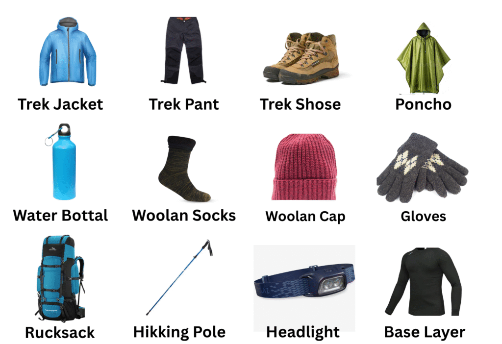
Trekking gear on rent
Pin Parvati Pass Trek
Pin Parvati Pass Trek DifficultyDifficult Duration 11 Days Maximum Altitude17,500 ft Base Camp Manali Best Time To visit July-August TREK PACKAGE RS 39,000 + 5% GST 11 Days Trekking 110 Km Pick Up Point: Manali Payment Mode: Cash, UPI, Bank Transfer Book Now Trek Info Region :- Himachal Pradesh Snow: December to March Trekking Km: 110 Kms Need Help? Call us on 9045089649 Overview About Trek Highlights Brief Itinery Detailed Itinerary How To Reach Cost Term Cancellation Things To Carry FAQs Risk & Response Secure Travels Guidelines Check Available Dates Weather Forecast The weather during April, May and June is mostly cool and pleasant but gets chilly and cold during winters. Have any Query? Call Us on 9045089649 Pin Parvati Pass Overview The Pin Parvati Pass (sometimes spelled Pin Parvati Pass) is a 5,319-meter mountain pass in Himachal Pradesh, India. From the woodland and green meadows of the Parvati Valley to the Buddhist communities of the Trans-Himalayan region of Spiti, the Pin Parvati Pass trek offers the most stunning crossings. You’ll be taken aback by the stark contrast in scenery, culture, plants, and fauna. In just a few hours, you’ll go from the frigid, dry upland desert of Spiti to the lush biodiversity of Parvati Valley. The bird’s eye vista from the Pin Parvati Pass will take your breath away. The Pin Parvati Trek is a once-in-a-lifetime journey that takes you from Tunda Bhuj to the marshlands of Mantalai to the alpine meadows of Odi Thach, dense forests near Kheerganga, and glaciers near the Pass. The optimal blend of Hill, Desert, and Jungle has been described. The majority of the trekking point base camps are located in Kullu and Manali. Because those locations are easily accessible and well connected to the rest of the country. About Pin Parvati Trek The Pin Parvati Pass journey is without a doubt one of the most enticing trans Himalayan treks. This arduous and strenuous trail is only for experienced and physically active hikers who have completed at least two, if not three, high Himalayan multi-day camping treks. Spiti’s trans Himalayan valleys were historically difficult to reach, but the Pin Parvati pass route cuts the distance between the Kullu and Spiti valleys in half. The trail was first offered to hikers in 1993. The walk is rigorous and difficult, but the region’s splendour makes it one of the most popular Trans-Himalayan treks. Trek Highlights On both sides of the pass, this amazing trek offers landscapes that are radically different. The remarkable contrast between the barren and rain-streaked Pin valley (Spiti side) and the lush green Parvati valley is shown by this constantly snowbound route (Kullu side). On this once-in-a-lifetime trek, hikers will encounter dense forests, hot springs, grazing meadows, meandering streams, moraines and glaciers, snow-capped peaks, coloured mountains, and much more. Kullu Eiger, Parvati South, Kangla Tarbo, Kullu Makalu, and West Horn are the primary peaks visible. Brief Itinerary Day 1: Manali to Barshaini and trek to Kalga • Manali to Barshaini and trek to Kalga• Manali to Barshaini 4 – 5 hrs drive• Barshaini to Kalga 1/2 hr trek• Lunch at Manikaran (Stoppage for 1 hr)• Leave Manali at 10 am• Bring left luggage separately so that without wasting time we will leave Manali on time• Networks are available at Kalga• Some parts of trek through apple orchid• Stay in home stay Day 2: Kalga to Kheerganga •Altitude Gain: 500m/ 1,650ft• Stay in tents/ local rest house• No Network available• Hot water spring at Kheerganga• Trek along with Parvati River• Will get much maggi point on the way• Mixed forest of Pine, Oak, Horse chestnut, Wall nut• Less steep ascent, more of gradual ascent Day 3 : Kheerganga to Tunda Bhuj • Camp setup takes time due to erratic availability of water, be patient• Gradual ascent but tiring . 3 small stream with small bridge be careful• No shops on the way . Last day of the forest. Day 4: Tunda Bhuj to Thakur Kuan • Altitude Gain: 200m/ 650ft• Most beautiful campsite of the trek• Tricky and rocky patch on the way so walking together is mandatory• After the tricky patch very steep ascent for 1 hr Day 5: Thakur Kuan to Odi Thach • 9 km trek 5-6hrs• Altitude Gain:250m/750ft• Easiest day of the trek <br• Pandu Bridge (Most tricky patch) comes just after 1.5 hrs of trek, to cross that bridge everyone has to be together . Most of the trail is flat walk• Water points are available before the Pandu Bridge• Very windy campsite Day 6: Odi Thach to Mantalai Lake • Altitude Gain:- 350m/ 1,200ft• After half hour from Odi Thach a big ground comes, cross that ground from left side (ground id very muddy)• Moraine area start just after crossing that ground• Moraine area is steep ascent• Mantalai Lake is the source of Parvati River• Small temple of lord Shiva at Mantalai Lake, from temple campsite is 45 minutes far.• Chances of getting AMS is high, keep yourself hydrate• Swimming in the lake is not aloud and not advisable Day 7: Mantalai Lake to Summit Camp • Altitude Gain:- 800m/ 2,700ft• exhausted day . Most of the part is very steep ascent• Only two water points are available• Just after 30 to 40 minutes of trek first water stream comes, keep floaters handy • After 3 1/2 hrs one more stream crossing• Chances of missing is very high, never walk alone• Camp site is most uncomfortable, camping will be on rocks Day 8 : Summit Camp to Pin Parvati Pass • Altitude Gain:- 350m/ 1,150ft• Altitude Loss:- 850m/ 8,850ft• Stay on summit maximum for 15 to 20 minutes• Today don’t make your own route on snow, always fallow trek leader or guide (craves area)• Today’s descent is more tricky and tiring then ascent• One stream and one river crossing keep floaters handy and cross under the guidance of your trek leader• After river crossing camp site is one hour far Day 9: Pin Base to Tiya • Altitude
Spiti Valley Bike trip
Spiti Valley DifficultyDifficult Duration 10 Days Maximum Altitude14, 931 ft Base Camp Manali Best Time To visit April, May, Sep, Oct Previous Next TREK PACKAGE RS 35,000 + 5% GST 10 Days Trekking 0 Km Pick Up Point: Delhi Payment Mode: Cash, UPI, Bank Transfer Book Now Trek Info Region :- HImachal Pradesh Snow: December to March Trekking Km: 0 Kms Need Help? Call us on 9045089649 Overview About Trek Highlights Brief Itinery Detailed Itinerary How To Reach Cost Term Cancellation Things To Carry FAQs Risk & Response Secure Travels Guidelines Spiti Valley Far away from the crowd in the silent bed of the Himalaya lying in peace where the tourist are always welcome “SPITI VALLEY” (Himachal Pradesh) You can reach out spiti from many means of transportation. If you are from Dehradun, you can follow the road to Shimla, where you can find some traffic, which is obvious, and then Kalpa to Kaza (the capital of Himachal Pradesh), leading straight to Spiti. Do take a guide along the way. Spiti lies between Tibet and India. About Spiti Valley There are two ways to reach spiti valley one is from Manali and the other one is from Kinnaur. But is winters i.e. from December to March the Way from Manali is closed due to heavy snowfall because of kunzum pass which is at a altitude of 4700m above sea level. Once you reach spiti valley, let me introduce you to the mountain food “chol and mutton” and Himachali Dham a famous dish. Tourist also stay at Kalpa to see Kailash mountain and parvati Peak; it’s a beautiful range The best part about Kalpa is that the mountains, the Himalayas, are just in front of you. They are high in altitude, and face-to-face with you, they are so huge. After Shimla district ends, a new path starts known as Kinnaur, the way to Spiti. There are mountain cuts on that route, and the roads are fabulous. Till Kinnaur, there are safety railings on the edge of the road constructed by the Himachal government. It takes almost 2 hours from Tapri to reach Kalpa, which is at an altitude of about 2900 m in the Himalayan range. Pin Valley and Reckong Peo are very famous in Kalpa. There is a Kailash Range, also known as Pir Pranjals, and the maximum altitude is 6050–6500 m. Trek Highlights Pin Valley and Reckong Peo are very famous in Kalpa. There is a Kailash Range, also known as Pir Pranjals, and the maximum altitude is 6050–6500 m. From pooh you have to climb a whole mountain and change the altitude of almost 1500 meters and then you can stop at Kangri Dham where you can stop and have “Rajma-Rice” which is again very famous go to go lunch. Once you reach Tabo, the Tabo Monastery it has great culture its one of the oldest monasteries in India and the oldest functioning monastery. It is one of the most cultural heritage point of spiti as a valley you can fine years old statues. Tabo religious community is arranged in the town of Tabo of Spiti valley, Dist. Lahaul-Spiti (H.P.) at 3280 meters elevation close to the Tibet line, only noth of sutluj River. Majestic Buddha Sitting Right There in between the Great Himalayas. Come to the Lanza Valley and Definitely Visit and pay Respect and Take your Blessings from Lord Buddha. Brief Itinerary Detailed Itinerary Day 1: Delhi to Manali The Spiti Valley Bike Trip expedition begins in Delhi, where our team picks you up at a pick-up point and takes you to the Valley of the Manari Gods. The drive from Delhi to Manari takes about 1112 hours. With a passion and passion for the Spiti Valley Bike Tour, it’s definitely fun. When driving at night, Volvo will take care of your comfort issues. Day 2: Arrive at Manari Local City Tour We arrive in Manari early in the morning and settle down in the room for a break. The bike will then be passed to you with complete information on the routes, maps, destinations and regulations provided by our team. Now you are ready to break through the local Manari in the city. Here, the fascinating natural beauty is mixed with historical and mythical elements. Hadimba Temple, Tibetan Monastery, Sanctuary, Old Manali (swaying eucalyptus trees, charming streets, cute little restaurants, small fox markets, cafes serving your favorite continental dishes), Manumaharishi Temple are all worth visiting (It is the only temple in India. Rishimanu, named after the city). After enjoying delicious local Manari cuisine, spend the night at the hotel. Day 3: From Manari to Lampuru After a delicious breakfast, we travel a distance of 197 km, with all the modern conveniences and can be used as a stopover before a long journey to Lahore Spiti. Lampuru is the center of small and medium-sized enterprises. The Sutlej River is lower than its surroundings. The first day of your trip from Manari ends with your arrival at Lampuru. Spend the night in a tent in a tent under a dazzling star-studded sky in an exhilarating campfire. Day 4: From Lampuru to Chitokuru After a delicious breakfast, head to Chitkul, the crown of Kinnaur. If you drive to the Chitokul Valley, the Baspa River is on your right. On the way, you will pass the village of Lac Cham. There are many campgrounds in the apple orchards along the Baspa River. The largest village in the Baspa Valley of Himachal Pradesh, at an altitude of 3450 meters (11,345 feet). It is the last inhabited village near the border between India and China. This is the end of the road in India. When you arrive at Chitkul, spend the night in your tent. Day 5: Chitkul to Tabo We begin riding towards Tabo, a little town on the banks of the Spiti River in the Lahaul and Spiti area of Himachal Pradesh, India. Tabo is a customary Himalayan town in Himachal Pradesh, India, situated on the Rekong Peo
Bhuran Ghati
Buran Ghati Trek GradeModerate To Difficulty Duration 7 Days Maximum Altitude15,000 ft RegionHimachal Pradesh Best Time To visit June To October Previous Next TREK PACKAGE RS 20,500 + 5% GST 7 Days Trekking 26 Km Pick Up Point: Shimla Payment Mode: Cash, UPI, Card Book Now Trek Info Region :- Himachal Pradesh Snow: December to March Trekking Km: 26 Kms Need Help? Call us on 9045089649 Overview About Trek Highlights Brief Itinery Detailed Itinerary How To Reach Cost Term Cancellation Things To Carry FAQs Risk & Response Secure Travels Guidelines Buran Ghati Overview The Buran Ghati hike is designed specifically for the thrill-seeker in you. This is a hike that will provide you with an overall view of the mountain range, woodlands, and meadows, all of which will undoubtedly excite you to no end. A beautiful view of the Dayara meadows will meet you, with snow-capped mountains in the background, and you will be delighted to see such diverse campsites, which are a photographer’s dream. Buran Ghati is a well-known trek in the trekking world, offering a plethora of magnificent sights along the way. With the various scenery, it has to offer, this walk will undoubtedly revitalize you. When you go through the thicker and denser Oak and Pine forests, they appear artistic. One of the trek’s highlights is the Chandranahan lake, which is tucked at a high elevation. This lake is considered sacred by many residents in the area. The view from both sides of the Buran Pass is spectacular. After spending some time at the lake, you’ll go on an altitude hike nearby. If you take this walk-in June, there may be a substantial amount of snow on the trail, which will alter the landscape’s appearance. About Buran Ghati Trek If you are looking for an extraordinary trek experience, Buran Ghati Trek is for you. The base camp of the Buran Ghati trek lies at Janglik. Janglik is a peaceful and mountain surrounding village. All the major equipment that you’ll need for the trek will be provided over here at the base camp. This Path is completely surrounded by oak trees. Chandlanhan Lake is another attraction of the Buran ghati trek. This Lake remains frozen mostly throughout the year. The valley is filled with an abundance of flora and fauna. The waterways and the bridges that connect the way look as if it is straight out of a movie. This area produces an abundance of apples, pears, apricots & peaches. Buran Pass stands tall at the height of 15059 feet.360 fisheye lens is recommended to capture amazing pictures. Trekking shoes and snow boots are recommended to tread over the thick snow once you pass the second checkpoint on this trek. This trek is recommended for people who performed at least one physically challenging Himalayan trek. Trek Highlights The path from the base camp to the 1st camp is filled with bugs and crossing oak forests. You might have heard the famous saying that the journey matters more than the destination the scenic views will make you realize that the saying is true. If you are fascinated by snow you’ll have stories to tell about Dhunda. Completely covered with ice Dhunda lies at a very high altitude and this is where camps are set up in the mountain shadow area. With the captivating view and all the hardships that you might have come across on your way, everything will start to make sense and you’ll commend yourself for making it this far. Brief Itinerary Day 01- Shimla to Janglik • Altitude:- 2,800m/9,200ft• Distance:- 160 km, 9-11 hours (Drive)• Pick-up:- Shimla Old Bus Stand at 6.30 am• Transportation is included in the cost• Last ATM:- Rohru• Phone Network:- Rohru• Breakfast and lunch excluded, dinner included• Shimla – Rohru: 115 Km Rohru to Chirgaon: 15 km Chirgaon to Tangnu: 20 Tonglu to Janglik: 10 Day 02- Janglik to Dayara Thatch • Altitude:- 3,400m/11,150ft• Trek:- 4 km, 5-6 hours• Grade:- Moderate ascent• Sources of water are available on the way• You will cross a few shepherd’s huts on the way• Trek through pine, Oak, deodar forest, and meadows• You will be given some snacks and a hot lunch at the site• In the evening climb some hillocks for better acclimatization• Night Stay:- Tent (twin sharing) Day 03- Dayara Thatch to Litham • Altitude:- 3,600m/11,800ft• Trek:- 3 km, 3-4 hours• Grade:- Easy gradual ascent and then descent• Sources of water are available on the way• Trek through dense forests, meadows, and some brooks• Today you will see the Silver Birch (Bhoj) forest and Chandranahan waterfall• Views of the snow-capped mountains of the Dhauladhar range• Hot lunch at campsite Day 04- Acclimatization day, visit to Chandranahan Lake • Altitude:- 4,200m/13,800ft• Trek:- 3 km (Each way), 6-7 hours• Grade:- Difficult, Steep ascent and descent• Star early in the morning• Sources of water are available on the way• Small glacial tarn• Chandranahan is a group of 7 lakes• You can see up to 3 lakes• Hot lunch at campsite Day 05- Litham to Dhunda • Altitude:- 4,000m/13,100ft• Trek:-4 km, 5-6 hours• Grade:- Moderate, Mixture of gradual & steep ascent• Sources of water:- Streams along the trail• Pass is visible from the campsite• Trail is well marked by the shepherds• Hot lunch at campsite Day 06 – Dhunda to Munirang (River camp) via Buran Ghati Pass • Altitude:- 3,600m/11,800ft via 4,550m/15,000ft• Trek:- 7 km 10-11 hours• Grade:- Difficult, Steep ascent and descent• Carry at least 2 liters of water from the campsite• Ascent and descent both is technical (Always be with Trek leader and other support staff)• The other side valley is full of junipers and crested shrubs• Camp nearby the river and farmer, hut• Packed lunch on the way, evening snacks at campsite Day 07 – Munirang (River camp) to Barua village, Drive to Shimla • Altitude:- 2,000m/6,600ft• Trek:- 5 km, 4-5 hours• Grade:- Easy, gradual descent• Only 3 water sources on the way, carry 2 liters of water• The Trail is well-marked• Cross
Hampta Pass
Hampta Pass Trek DifficultyEasy To Moderate Duration 5 Days Maximum Altitude14,000 ft Base Camp Manali Best Time To visit Sep, Oct, Nov Previous Next TREK PACKAGE ₹ 8,500/- Ex Manali(5N/6D) + 5% GST 05 Days Trekking 26 Km Pick Up Point: Manali Payment Mode: Cash, UPI, Bank Transfer Book Now Trek Info Region :- Himachal Pradesh Snow: December to March Trekking Km: 26 Kms Need Help? Call us on 9045089649 Overview About Trek Trek Highlight Brief Itinerary Detailed Itinerary How To Reach Cost Term Cancellation Policy Trek Essentials Fitness Risk and Response Secure Travels Guideline The Hamta Pass is situated at an altitude of about 14,000 feet above sea level, surrounded by huge snow-capped mountains. On this entire Hmata Pass Trek, apart from beautiful deodar trees, you will see waterfalls, glaciers hanging from snow, lakes, pinewoods, and small soft meadows, which make this entire trek even more thrilling and beautiful. The Hamta Pass Trek starts from the beautiful city of Manali in Himachal, which is also a world-famous tourist destination, where thousands of tourists from all over the country come every year. This whole city is covered with Deodar trees, which adds to the beauty of this city. In the same season, there is snowfall here which makes the tourists even more thrilled. The Hamta Pass is situated between the Chandra Valley and the Kullu Valley of Lahaul. It takes about 5 days to reach and leave the Hamta Pass Trek from here. This trek is named after a small village Hamta which falls in the middle of this Trek. The Hamta Pass is mostly used by the shepherds living in the Himalayan region. During summer, when the land in and around Lahaul becomes barren, the shepherds take their goats to the grasslands here to graze in these grasslands. This Hamta Pass Trek starts from Manali and ends at Chataru near Chandratal. You have to go along the Hamta Pass where in the middle you can see the beautiful weather and green natural shade changing every moment, which gives tourists a look. Takes you to a different world. For those who like adventure sports, this trek is no less than a surprise. Here the icy winds blow every moment, seeing the mist of white clouds between the standing pine trees around and it seems as if you are going on the way towards heaven. Seeing all this, you will not even believe that you are going to travel on any Trek. This experience will never be forgotten in your life. On this Hamta Pass Trek, like other Trek, you do not get the necessary things like food, drink, T-House, and mobile connection anywhere in the middle. Mobile networks can also be available to you only till Prini. After that, you are complete with nature and in nature’s lap. But the way to go here is good, due to which you can easily complete the Hmata Pass Trek. This entire Hamta Pass Trek is about 26 km, on it takes about 5 days to reach and leave. The best season to visit the Hamta Pass trek is from April to October, after which there is a risk of slipping on the trek due to the rainy season. From April to October, the weather here is mostly clear, due to which you can enjoy the nature here. To go on this Trek, you have to go along the Chandra River, in the middle of which you get a chance to see small meadows, waterfalls, and snow-capped mountains of the beautiful Dhauladhar. You can see the beautiful hills of Dev Tibba, Indrasen Peak, Indarkila Inderkila, and the surrounding beauty of snow-capped mountains. The height of Hamta Pass is about 14,000 feet. Day 1: Manali To Chika • Altitude: Jobra – 3000 m/9,800 ft to Chika 3100 m/ 10,100 ft.• Drive: 2 hr to Jobra from Manali• Trek Distance: 2 km Duration: 45 minutes from Jobra• Enough water through the trail• Easy to moderate trail• Stay in a tent• Pick Time: 12 pm• Reach Chika campsite by 5 pm Day 2: Chika to Balu Ka Ghera • Altitude: 3,600 m/ 11,900 ft.• Trek Distance: 8.5 km | Duration: 5 to 6 hrs.• Altitude Gain: 500 m/ 1,800 ft.• Moderate trail, gradual ascent.• A packed lunch will be provided• Enough water on the way.• River crossing, boulder walk, and colorful tiny flowers on the way. Day 3: Balu Ka Ghera To Shea Goru Panoramic Mountain Views • Trek Distance: 7 km | Duration: 10 hr• Altitude Gain: 300 m/1,000 ft• No water point on the way(depends on the condition of the snow)• First 1 hr gradual ascent then steep ascent till the pass• Packed lunch at the pass, enjoy the view of Indrasen Peak• Around 2 hrs of steep descent and 1 hr of flat walk from the pass to the campsite• The coldest part of the trek• Stay in a tent Day 4 : Shea Goru To Chatru • Trek Distance: 7 km | Duration: 5hr• Drive Distance: 49 km 3 hr to Chandratal and back to the campsite, either on day 4 or day 5 (depending on road and weather conditions)• Altitude Loss: 550 m/1,900 ft• Gradual descent on the moraine• Start early in the morning• 2 to 3 water sources on the way• Hot lunch at campsite Day 5: Chatru To Manali • Breakfast at the campsite• Lunch on the way• Make your further plans from Manali Day 1: Manali To Chika The journey begins in Manali, where you will be picked up and driven to Jobra in a car. Manali, at 6,700 feet above sea level, is a wonderful site to acclimate before beginning the trip. Before arriving at Jobra, the route takes you around 40 hairpin bends and takes about 2 hours. Throughout the journey, you will be able to appreciate the grandeur of the Kullu Valley. Jobra serves as the starting point for your journey to Hampta Pass. It is located at a height of 9,800 feet, with the trek to Chika taking you to a height of 10,100 feet.Today’s hike will take you through a mixed woodland of pine and green maple along the banks of Rani NallahThe journey begins at the Allain Guhugal Hydel Project junction and continues through a forest of Pine trees and other conifers such as Maple, Oak, Deodar, and Toss after crossing the